Showing 1993 items matching transport - roads
-
 Orbost & District Historical Society
black and white photograph, 1913
... transport roads road-maintenance Country-Roads-Board... in early 20th century. transport roads road-maintenance Country ...This photograph shows Country Roads Board men clearing a bush track at Hospital Creek. Their vehicle was bogged. The y Roads Board was formed in 1913 1910 it had become apparent that there was a need for a central roads authority to take over responsibility from the Board of Lands and Works for the care and management of the main roads of the state of Victoria. Because there was no consistent and systematic policy for road maintenance Victorian roads were in a deplorable condition. At this time the use of the motor car accentuated the demands for better roads. As a result of these needs the Country Roads Act 1912 was proclaimed in 1913 providing for the establishment of the Country Roads Board as a central road authority with responsibility for those roads within the State considered to be main roads. the C.R.B. was responsible for the construction of roads and bridges including the Snowy River road bridges in Orbost.. This is a pictorial record of transport difficulties in East Gippsland in early 20th century.A large black / white photograph of three men clearing a bush track with a motor vehicle behind them.transport roads road-maintenance country-roads-board -
 Hume City Civic Collection
Photograph, late 1980s
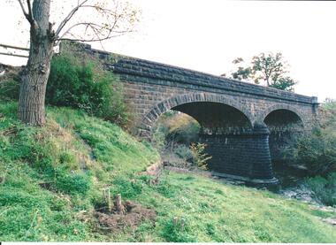
... was rebuilt in the early 1970s. transport roads and bridges jacksons ...The road bridge over Jackson's Creek in Sunbury was built in 1870 and was in use until a wider bridge was built when Sunbury Road was rebuilt in the early 1970s.A coloured photograph taken from the NE side of the river bank of a complete view of the bluestone bridge at Macedon Street. The two eliptical arches and the protruding pylon as well as the underside of the bluestone span are clearly visible.transport, roads and bridges, jacksons creek, harris, thomas lascelles, george evans collection -
 Port Melbourne Historical & Preservation Society
Document - 2011 Melway Greater Melbourne Street Directory, 2011
... transport - roads... streets lanes and footpaths natural environment transport - roads ...2011 editions of Melway Greater Melbourne Street Directory Top quarter white, bottom blue background with photo of citybuilt environment, engineering - roads streets lanes and footpaths, natural environment, transport - roads, streets, mapping, greater melbourne -
Port Melbourne Historical & Preservation Society
Newspaper - Rescue of Mr Hendy by Arthur Downer, J Kitchen & Sons driver, 9 Feb 1918
... Transport - Roads... - Manufacturing Transport - Roads Sport - Swimming J Kitchen & Sons Pty ...Photocopy of download of item from Port Melbourne Standard (Vic 1914 - 1920), Saturday 9th February 1918. The rescue of a Mr HENDY by J Kitchen and Sons driver, Arthur DOWNERThe Royal Humane Society of Australasia written in ink at the bottom of the pageindustry - manufacturing, transport - roads, sport - swimming, j kitchen & sons pty ltd, arthur downer, port melbourne swimming club, mr hendy -
Port Melbourne Historical & Preservation Society
Book - Morgans Street Directory, 1948
... transport - roads... 1948 Morgans Street Directory transport - roads john may les ...1948 Morgans Street Directorytransport - roads, john may, les murphy -
Port Melbourne Historical & Preservation Society
Book, Universal Business Directories (Aust) Pty Ltd, Universal DeLuxe Streets Directory, 1959
... Transport - Roads... edition. Red and Buff cardboard cover, red binding. Transport ...1959 Streets Directory for Melbourne City and Suburbs including large scale maps, hospitals, schools, police stations, town halls, telephone booths, tram stops, railways. Fifth edition. Red and Buff cardboard cover, red binding.transport - roads, street directory -
Port Melbourne Historical & Preservation Society
Book - Collins Melbourne Street Directory, 1950s
... transport - roads... Stuart - used by his father, William Raeburn Stuart. transport ...From Glen Stuart - used by his father, William Raeburn Stuart.Collins Melbourne Street Directory c1950stransport - roads, william raeburn stuart -
Port Melbourne Historical & Preservation Society
Document - Submission, Inquiry into "Land Transport to Webb Dock", 1981
... transport - roads... authority transport - railways transport - roads local government ...Submissions concern impacts, implications and future directions regarding freight movement into and out of Webb Dock.Submissions and transcripts from the State Development Committee "Inquiry into Land Transport to Webb Dock", 1981 City Of Port Melbourne submissionport of melbourne authority, transport - railways, transport - roads, local government - city of port melbourne, webb dock, urban freight group, bill saggers -
Port Melbourne Historical & Preservation Society
Document - Submission, Inquiry into "Land Transport to Webb Dock", 1981
... transport - roads... of melbourne authority transport - railways transport - roads local ...Submissions concern impacts, implications and future directions regarding freight movement into and out of Webb Dock.Submissions and transcripts from the State Development Committee Inquiry into "Land Transport to Webb Dock", 1981 Bill Saggers submission"Bill Saggers highlighted aspects of the written submission to be presented verbally by Bill Saggers"port of melbourne authority, transport - railways, transport - roads, local government - city of port melbourne, webb dock, urban freight group, bill saggers -
Port Melbourne Historical & Preservation Society
Document - Submission, Inquiry into "Land Transport to Webb Dock", 1981
... transport - roads... of melbourne authority transport - railways transport - roads local ...Submissions concern impacts, implications and future directions regarding freight movement into and out of Webb Dock.Submissions and transcripts from the State Development Committee "Inquiry into "Land Transport to Webb Dock", 1981 Urban Freight Group submission"RPW"port of melbourne authority, transport - railways, transport - roads, local government - city of port melbourne, webb dock, urban freight group, bill saggers -
Port Melbourne Historical & Preservation Society
Document - Transcript, Inquiry into "Land Transport to Webb Dock", 1981
... transport - roads... of melbourne authority transport - railways transport - roads local ...Submissions concern impacts, implications and future directions regarding freight movement into and out of Webb Dock.Submissions and transcripts from the State Development Committee "Inquiry into "Land Transport to Webb Dock", 1981 Transcript of Proceedings, 25.08, 1981"RPW"port of melbourne authority, transport - railways, transport - roads, local government - city of port melbourne, webb dock, urban freight group, bill saggers -
Port Melbourne Historical & Preservation Society
Photograph - COR road tanker, Beach Street, Port Melbourne, Douglas Smallpage, 1940s
... Transport - Roads... Transport - Roads Business and Traders Commonwealth Oil Refineries ...B&W photos of various locations in Port Melbourne COR road tanker on Beach St in 1940sSeveral have descriptions of locations in pencil on rear of photostransport - roads, business and traders, commonwealth oil refineries, cor -
Port Melbourne Historical & Preservation Society
Book - Mac's Trade Professional & Street Directory of Melbourne, 1940s
... transport - roads... & Street Directory of Melbourne, early 1940's transport - roads ...Mac's Trade Professional & Street Directory of Melbourne, early 1940'stransport - roads, edwin whiting -
Port Melbourne Historical & Preservation Society
Book - Robinson's Street Directory of Melbourne, 1940s
... transport - roads... transport - roads edwin whiting H E C Robinson ...Robinson's Street Directory of Malbourne, early 1960stransport - roads, edwin whiting -
Port Melbourne Historical & Preservation Society
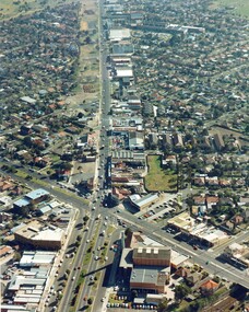
Photograph - Aerial view showing route of Lower Yarra Crossing Project (West Gate Bridge), Apr 1966
... transport - roads... gate bridge transport - roads engineering - bridges Department ...Black and white aerial photomap showing the proposed route of the Lower Yarra Crossing Project, later to become the West Gate Bridge and Freeway. April 1966'Lower Yarra Crossing Project' '296769'west gate bridge, transport - roads, engineering - bridges -
 Port Melbourne Historical & Preservation Society
Document - Pre-paid Toll Vouchers for West Gate Bridge, 1980
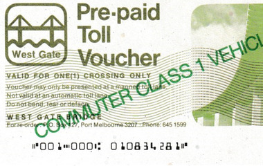
... Transport - Roads... Transport - Roads ...From the collection of Warren DOUBLEDAY. Bridge tolls were imposed from its opening in 1978 until they were removed in 1985.Two unused white Pre-paid Toll Vouchers.' Commuter Class 1 Vehicle Only' is written in green across both the front and back, The West Gate logo is in the top left corner.transport - motor vehicles, built environment - west gate bridge, transport - roads -
 Port Melbourne Historical & Preservation Society
Photograph - Graham Street towards Albert Park, Reverend Donald LANGFORD, June 1973
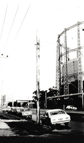
... Transport - Roads... Environment - Industrial Transport - Roads Education - Secondary ...Taken from the corner of Seisman Place looking towards Albert Park, the photograph was taken before the demolition of the gasometer shown on the on right. The original Albert Park High School can be seen behind the Pickles Street sign.B & W photograph of Graham Street, Port Melbourne looking towards Pickles Street.built environment - demolition, built environment - industrial, transport - roads, education - secondary schools, gasometer -
Port Melbourne Historical & Preservation Society
Photograph - Various photos related to John James Gilcrist, John Gilcrist, 1940s - 1950s
... Transport - roads... and Wharves - Princes pier Built Environment Transport - roads John ...From John Gilcrist via Janet Bolitho13 photos from John Gilcrist showing his father, John James Gilcrist, at Station Pier and Princes Pier, a view from the Shrine of Remembrance, Centenary Bridge, and his father and mother, Eileen Mary Gilcrist at their home at 16 McCormack Street Port Melbourne .01 - Princes Pier, Taroona, Port Hobart .02 - View from Shrine overlooking Albert Park Lake .03 - Between piers .04 - Princes Pier at night .05 - From Station Pier West finger pier .06 - House at 16 McCormack Street. (No. 12 McCormack Street also shown) .07 - Centenary Bridge1949-50 .08 - Outside 16 McCormack Street, showing Singer car. (Nos. 22, 24 & 26 McCormack Street also shown) .09 - John and Eileen Gilcrist in backyard .10 - South side of house at 16 McCormack Street .11 - South side of house at 16 McCormack Street .12 - Photo of Edwards Park .13 - East side of house at 16 McCormack Street Refer also to hand drawn plan of house and outbuildings at catalogue no. 2763piers and wharves - station pier, piers and wharves - princes pier, built environment, transport - roads, john gilcrist, john james gilcrist, mary eileen gilcrist, mccormack street -
Port Melbourne Historical & Preservation Society
Book - Melway Greater Melbourne Street Directory, Melway, 1990 - 2009
... transport - roads... transport - roads melbourne streets mapping Melway ...Four editions of Melway Greater Melbourne Street Directory .01 Edition 20 (1990) - Reg Yellow and green vertical banded cover .02 Edition 24 (1994) - Green, orange, white cover .03 Edition 32 (2005) - Dark and light blue cover .04 Edition 36 (2009) - White, red and black coverbuilt environment, engineering - roads streets lanes and footpaths, natural environment, transport - roads, melbourne, streets, mapping -
Port Melbourne Historical & Preservation Society
Document - Reports, Planning, development and traffic management, Loder & Bayly, 1974 - 1978
... transport - roads... planning transport - roads built environment - commercial built ...12 surveys re planning, development and traffic management carried out by Loder & Bayly, August 1974 to February 1978local government - city of port melbourne, town planning, transport - roads, built environment - commercial, built environment - zoning, loder & bayly, glen cosham -
 Whitehorse Historical Society Inc.
Machine - Horse Drawn Scoop
... was rotated and emptied. rural industry agriculture transport roads ...Used by Mr. Livermore, Snr, and his brothers to construct dams on their properties and for neighbours. It was filled by raising the wooden handle slightly so that the cutting edge bit into the earth. It was tipped by raising the handles higher so that the cutting edge bit in so deeply that the scoop was rotated and emptied.Horse drawn earth moving scoop used for construction of dams, irrigation channels, roads, etc on a farm, orchard, or roads, or where earth needs to be moved. Scoops had no tipping mechanism and needed considerable effort to empty them.rural industry, agriculture, transport, roads -
 Port Melbourne Historical & Preservation Society
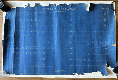
Plan, Pt Melbourne Cable Tramway, 1890s
... Transport - Roads... crayon or pencil Transport - tramways Transport - Roads ...One of three sheets of blueprints showing street configuration in Beach Street and Sandridge Road along Port Melbourne cable tram route. Indistinguishable signature of 'George ------ Esq., lower rightNotations in red crayon or penciltransport - tramways, transport - roads -
 Ballarat Tramway Museum
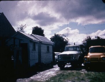
Slide - 27 mm sq slide/s, D. Wiseman, the two SEC transportable road sheds and two trucks, Sep. 1971
... cardboard mount of the road roller, the two transportable road sheds... cardboard mount of the road roller, the two transportable road sheds ...Yields information about the appearance the equipment that was used by the SEC workers to maintain the roads, including the trucks, shelters and road roller.Colour 27 x 27 mm slide in a white Kodak duplicate cardboard mount of the road roller, the two transportable road sheds and two trucks stored at either the SEC depot or a SEC works depot. Photo from the collection of Lilian Butler.Has a note in ink on rear "Copies made from Mr. D. Wiseman's Slides"ballarat, tramways, trams, sheds, road works, track repairs, sec, jelbart, road roller -
 Phillip Island and District Historical Society Inc.
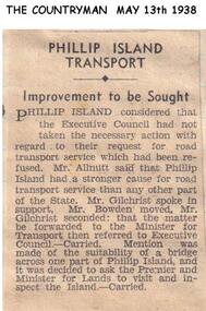
Newspaper clippings, 13/05/1938
... road transport...Article on need for road transport service for Phillip... for road transport service for Phillip Island. Newspaper article ...Newspaper article in The Countryman 13/5/1938Article on need for road transport service for Phillip Island.local history, documents, newspapers, road transport, phillip island, black & white newspaper clipping -
 Greensborough Historical Society
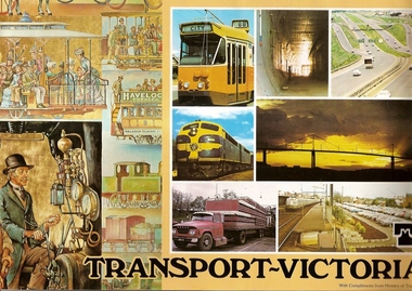
Book, Transport in Victoria, 1980s
... trams roads Ministry of Transport. Victoria. ...Each of these booklets details the history, changes and upgrades to transport in Victoria in the early 1980s and explains the role af government authorities such as the Country Roads Board. Item 707c describes the Melbourne Freight Terminal between Spencer Street and Footscray Road.An historical look at the development of transport in Victoria.A collection of 3 booklets on transport in Victoria. Item 707a: 16 pages, colour illustrations. Item 707b: 20 pages, colour illustrations.Item 707c: 8 pages, black and white illustrations (20 x 14.5 cm). railways, transport, victoria, trams, roads -
Stawell Historical Society Inc
Map, Roads Maintained by NGSC. Roads Maintained by Other Authorities, C 2020
... Roads Transport ...Printed Colour map of Norther Grampians Shire, with roads marked in colourNorther Grampians Shire COuncil. 1:200,000shire, roads, transport -
Port Melbourne Historical & Preservation Society
Document - Scrapbook, Newspaper cuttings relating to Port Melbourne, Edward C Crockford, Town Clerk, 1890s
... Melbourne Transport - Railways Transport - Tramways Engineering ...EC CROCKFORD's scrapbook from time he became acting Town Clerk (1892) until he left to serve South Melbourne (1909).Scrapbook kept by Port Melbourne Town Clerk EC CROCKFORD, 1890s: notebook with marbled board covers, 38 ruled pp, some empty. Back of book used upside down. Pasted with clippings related to municipal operation, and ads for contracts (in back). Insert: note on rateslocal government - town of port melbourne, engineering department - town of port melbourne, transport - railways, transport - tramways, engineering - roads streets lanes and footpaths, engineering - canals and drainage, amalgamation, piers and wharves - station pier, business and traders, sport - lawn bowls, health - general health, law, nightsoil, piers and wharves - railway pier, statistics, edward c crockford, town clerks, municipal elections -
 Whitehorse Historical Society Inc.
Photograph, Whitehorse Road, Blackburn, 2012
... on the right - 2012 whitehorse road blackburn roads transport ...Coloured photograph of Whitehorse Road Blackburn looking west, Surrey Road enters Whitehorse Road near the red building on the right - 2012whitehorse road, blackburn, roads, transport -
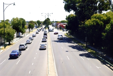
 City of Kingston
Photograph - Colour, c. 1982
... Moorabbin Roads Transport Infrastructure Handwritten blue ink: 82 ...This aerial photograph of South Road and Nepean Highway, Moorabbin shows the area where houses and shops on the south side of the Nepean Highway have demolished for the widening of the highway. The pressures of rapid urban development in Moorabbin and beyond, especially to the south of Moorabbin caused bottlenecks and delays, especially at the South Road and Nepean Highway intersection, hence the scheme to widen Nepean Highway.The pressures of rapid urban development in terms of people, housing construction, industrial development and commercial activity, in Moorabbin and beyond, especially to the south would put pressure on road infrastructure in the region. In the early 1980s, a major road expansion of the Nepean Highway was implemented to increase capacity on this major thoroughfare for vehicle commuters. Car use had also increased with commuters from the increasingly populous southern suburbs travelling to their place of work in the Melbourne CBD.Colour photograph of an aerial view of South Road and Nepean Highway, Moorabbin. The image shows houses on the south side of the Nepean Highway that have demolished for widening of road. It features housing and commercial buildings looking north towards Cummins Road.Handwritten blue ink: 82 - 5452 - 11 Handwritten red ink: 112% Handwritten black ink: Ch. 7nepean highway, south road, moorabbin, roads, transport, infrastructure -
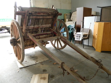 Kiewa Valley Historical Society
Tipping Dray
... tipping dray. john briggs. tawonga. german creek. road...The dray was pulled by a horse and used to transport road... to transport road building materials such as gravel. The tray carried ...The dray was pulled by a horse and used to transport road building materials such as gravel. The tray carried 0.7 of a cubic metre which would have weighed about 1 tonne (varying on the load being wet or dry).This tipping dray was owned by John Briggs who carried gravel on the Tawonga to German Creek Road from 1894 to 1895. Workers were paid 2/- (shillings) per day to cover sections that were called 'a paddock' resulting in workers finishing at 10 or 11 pm. The road opened on the 17th March 1896 at a cost of 1700 pounds. See KVHS 0960 for newspaper article re Tom Briggs and making (and photo) of the Tawonga Gap road.Old single axil wooden dray with wooden spoke wheels and a tipping wooden tray.tipping dray. john briggs. tawonga. german creek. road building. transport.